On BLM land, Elevation = 7976 ft. (2431 meters)
Highpoint of the Pahranagat Range
Driving Directions: On highway 93 south of the town of Alamo turn off the highway heading west about 0.2 miles north of milepost 32. This is south of the south end of Upper Pahranagat Lake. Reset your odometer and note the following points along this generally good, graded dirt road.
At 0.6 miles go through a cattle guard
At 4.3 miles there may be cows by a water tank
At 5.2 miles go left at a fork
At 5.8 miles there is an open gate
At 6.9 miles reach the crest of a pass
At 8.4 miles make a sharp right turn. You will be heading northwest
At 11.3 miles there are cows and blue water tanks
At 13.0 miles go left at a fork
At 18.5 miles go straight at a crossroads. The road gets rougher beyond here
At 22.0 miles pass Badger Spring (dry)
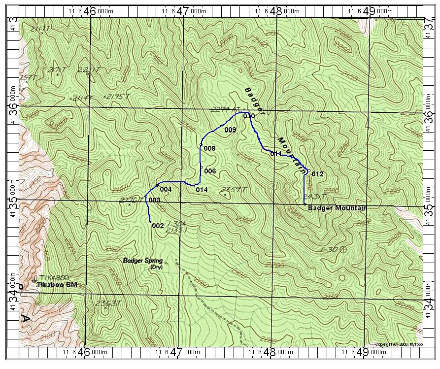
At 22.4 miles reach the end of the road. Limited camping here. This is point 002 on map.
Hiking Route: Head north to a natural saddle just east of point 2176 and then turn east up the slopes. At the top of the ridge near point 014 head north descending across pine-covered terrain. You'll go through a small drainage and up thicker, wooded slopes to point 009. Head east around the end of the big canyon on the west side of Badger and go toward the antenna on the northern summit. The highpoint is south at the end of the ridge. The round-trip distance is about 4.8 miles with a gain of about 1100 feet. It took me two hours to reach the top. 4/13 RLC There is a good report by Dean Molen on summitpost.