Mission Benchmark 3535 ft. (1077 m), Riverside County, California

In the Eagle Mountains, Prominence = 1075 ft.

Mission Benchmark is a prominent peak on BLM land between the Eagle Mountain mine and Joshua Tree National Park. To reach a suitable trailhead on the east side exit I-10 at Desert Center and go north. After about a tenth of a mile turn left on paved Kaiser Road. Follow this road for 10.7 miles and turn right onto a good graded dirt road (point M1 not shown on map) that will parallel the aqueduct. Drive for 2.9 miles north and stop at a siphon where there is a gap in the aqueduct. This is point M2 on the above map. Turn left and cross the dirt road on the west side of the aqueduct and then in about 20 feet turn left and look for the end of the dike. The ground is soft until you get up on the dike and four-wheel drive may be needed. This is seldom driven and you may want to get out of the car and look at the route by walking up on the road on the west side of the aqueduct. Once on the dike drive 0.7 miles to its end and then one can follow a faint track on hard ground for another 0.4 miles to a place to park at point M4 on the map. There is plenty of room to camp here.

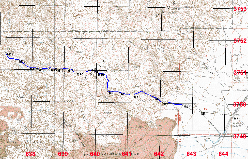
Hiking Route: Head west into the canyon which starts at point M5. The canyon is boulder-filled, but not that bad. At point M8 go left (west) at a divide and head up to a saddle with views into a large canyon (point M9). Go north here up the ridge and you should find an old miners trail which helps out. Follow this as it gains elevation and then curves west and descends to point M11. Leave the trail here and cross easy terrain with numerous small drainages to a crest at M12. Descend to the bottom of a ridge at M13. Climb the ridge to point M17 and then go west contouring around a small peak of 3360 ft. to a saddle at M18. The true summit is now in view and it is an easy walk to the top. This route is 9 miles round-trip with a gain of about 3200 feet including some of the up and downs. It took us 4 1/4 hours up and about 3 1/2 hours down. 11/13 RLC GPX file for this route. The UTM grid using NAD27 datum is shown on the above map. Higher res. map. This is a TIFF file. Print in landscape mode for best resolution.

The benchmark disk which was placed in 1960. Datasheet.