Located in the Barry M. Goldwater Marine Corps Test Range
Second highest peak in the Gila Mountains
Notes on Permits for the Barry M. Goldwater Range and Cabeza Prieta Wildlife Refuge: This peak is on the Barry M. Goldwater Range, West Side. Public entry for hiking and camping is allowed with a permit from the Cabeza Prieta Wildlife Refuge office in Ajo which regulates public entry. The permit will also allow you to drive across the Barry M. Goldwater Range to reach the Refuge. For information write or call the Refuge staff at: 1611 North Second Ave., Ajo, AZ. 85321. Phone: (520) 387-6483. Four-wheel drive vehicles are required. More information on permits is at my site: Cabeza Permits Note: Before driving in call the BMGR office in Yuma at: 800-979-0657.
Driving Directions: Take exit #14 on Interstate 8 which is Foothills Blvd. on the far eastern side of Yuma. Drive south to the end of the pavement which is Post "A" and the Range boundary. Be sure to have a full tank of gas and adequate water and supplies since there are no facilities in this large area. Note the following mileages starting from Post A at the boundary:
At 4.1 miles reach Post A2 and go left.
At 7.5 miles go left at a junction at Post A5.
At 9.6 miles go right at Post A6. This road is the old Camino del Diablo.
At 10.9 miles turn left at Post A7. The road is rougher from here on.
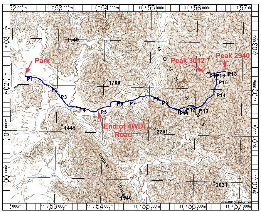
At 12.9 miles reach Post B9 and make a hard right at the post. We drove to point P1 on the map at 13.4 miles and camped, but the road does go 1.2 miles further and one could drive to the road end at point P5. The road is a bit rougher with big stones, so high-clearance is needed.
Hiking Directions: Start from P1 and follow the road to P5. Or if you parked at P5 follow a faint trail that has cairns now and then in the large canyon. Go right at a significant split at point P8. At point P10 turn north. The canyon will open up and one can follow it around a narrow S bend. Then head NE and finally north up a steeper slope to a saddle. There is a relatively easy scramble up to Peak 3012 from there. Back at the saddle you can go east up to Peak 2940 which is also a 300 ft. prominence peak. This route is about 8 miles round-trip from P1 with a gain of 2300 ft. Add another 360 ft. if you do the eastern peak. It took us close to 8 hours for the hike. 12/14 RLC